信息整理:图书馆
多时相遥感有着广泛的应用,其在农业、林业、气候和环境监测等诸多方面都有重要的作用。本期学术前沿以2011至今SCIE10年的相关主题论文为分析数据,分技术、应用主题和数据源三个方面揭示其研究趋势和研究热点。涉及的主题由文本挖掘工具CiteSpace词频统计获得。
图1为2011年以来多时相遥感应用相关文献按照技术、应用主题和数据源三个类别分别统计的年度发文量,三个领域的研究热度均持续上升,其中利用相关数据源开展应用的研究论文增长趋势最为明显。
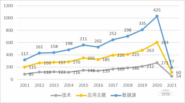
图1 多时相遥感应用三个类别的研究趋势
1.技术
根据词频统计,多时相遥感应用涉及的技术主要有影像分类、地理信息系统、机器学习、支持向量机、神经网络、光谱混合分析、图像识别7个关键词(主题),图2是近十年7个高频关键词的相关文献量分布。总体而言,涉及的主要技术类别是影像分类和机器学习类(包括深度学习、神经网络和支持向量机)。

图2 多时相遥感应用主要技术类别与文章数量
分析近两年该领域的ESI高被引论文或热点论文,则热点技术主要包括:
(1)影像分类
此处的影像分类包含各分类方法,如监督分类、非监督分类、人工神经网络分类、基于知识分类和面向对象分类等。

(2)机器学习(含“深度学习”)
(3)神经网络
(4)支持向量机

(5)地理信息系统
2.应用主题
根据词频统计,多时相遥感应用涉及的应用主要有土壤、变形、生物量、生物气候学、碳、生物多样性、降雨量和地震8个关键词(主题),图3是近十年8个高频关键词的相关文献量分布。整体而言,主要应用领域为变化检测、土壤、生物(生物量、生物气候学和生物多样性)和变形。

图3 多时相遥感应用主要应用领域与文章数量
分析近两年该领域的ESI高被引论文或热点论文,则热点应用主要包括:
(1)变化检测

(2)变形

(3)土壤

(4)碳(包括土壤有机碳、与气候变化相关的碳储量等)

(5)生物气候学

(6)降雨量

(7)生物量

(8)生物多样性

3.数据源
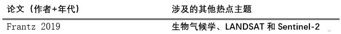
根据词频统计,多时相遥感应用涉及的数据源主要有LANDSAT、SAR(InSAR)、MODIS、LiDAR、Sentinel-2和UAV 6个关键词,图4是近十年6个高频关键词的相关文献量分布。总体而言,LANDSAT最为突出。

图4 多时相遥感应用主要数据源与文章数量
分析近两年该领域的ESI高被引论文或热点论文,则热点数据源主要包括:
(1)Sentinel-2

(2)Landsat
(3)SAR(InSAR)

(4)MODIS

(5)UAV
(6)LiDAR

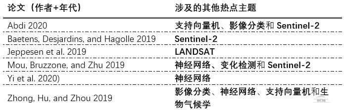
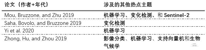
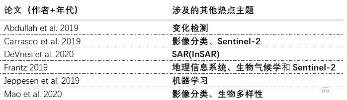
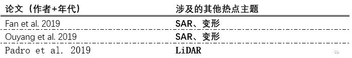
附:相关ESITOP论文(2019-)
Abdi, A. M. 2020. "Land cover and land use classification performance of machine learning algorithms in a boreal landscape using Sentinel-2 data."Giscience & Remote Sensing57 (1): 1-20.https://doi.org/10.1080/15481603.2019.1650447.
Abdullah, A. M., A. Masrur, M. S. G. Adnan, M. A. Al Baky, Q. K. Hassan, and A. Dewan. 2019."Spatio-Temporal Patterns of Land Use/Land Cover Change in the Heterogeneous Coastal Region of Bangladesh between 1990 and 2017."Remote Sensing11 (7).https://doi.org/10.3390/rs11070790.
Baetens, L., C. Desjardins, and O. Hagolle. 2019. "Validation of Copernicus Sentinel-2 Cloud Masks Obtained from MAJA, Sen2Cor, and FMask Processors Using Reference Cloud Masks Generated with a Supervised Active Learning Procedure."Remote Sensing11 (4).https://doi.org/10.3390/rs11040433.
Carrasco, L., A. W. O'Neil, R. D. Morton, and C. S. Rowland. 2019. "Evaluating Combinations of Temporally Aggregated Sentinel-1, Sentinel-2 and Landsat 8 for Land Cover Mapping with Google Earth Engine."Remote Sensing11 (3).https://doi.org/10.3390/rs11030288.
Chuvieco,E., F. Mouillot, G. R. van der Werf, J. San Miguel, M. Tanase, N. Koutsias, M. Garcia, M. Yebra, M. Padilla, I. Gitas, A. Heil, T. J. Hawbaker, and L. Giglio. 2019. "Historical background and current developments for mapping burned area from satellite Earth observation."Remote Sensing of Environment225: 45-64.https://doi.org/10.1016/j.rse.2019.02.013.
DeVries,B., C. Q. Huang, J. Armston, W. L. Huang, J. W. Jones, and M. W. Lang. 2020. "Rapid and robust monitoring of flood events using Sentinel-1 and Landsat data on the Google Earth Engine."Remote Sensing of Environment240.https://doi.org/10.1016/j.rse.2020.111664.
Efthimiou, N., E. Psomiadis, and P. Panagos. 2020. "Fire severity and soil erosion susceptibility mapping using multi-temporal Earth Observation data: The case of Mati fatal wildfire in Eastern Attica, Greece."Catena187.https://doi.org/10.1016/j.catena.2019.104320.
Fan, X. M.,Q. Xu, A. Alonso-Rodriguez, S. S. Subramanian, W. L. Li, G. Zheng, X. J. Dong, and R. Q. Huang. 2019. "Successive landsliding and damming of the Jinsha River in eastern Tibet, China: prime investigation, early warning, and emergency response."Landslides16 (5): 1003-1020.https://doi.org/10.1007/s10346-019-01159-x.
Frantz, D.2019. "FORCELandsat + Sentinel-2 Analysis Ready Data and Beyond."Remote Sensing11 (9).https://doi.org/10.3390/rs11091124.
Jeppesen,J. H., R. H. Jacobsen, F. Inceoglu, and T. S. Toftegaard. 2019. "A cloud detection algorithm for satellite imagery based on deep learning."Remote Sensing of Environment229: 247-259.https://doi.org/10.1016/j.rse.2019.03.039.
Lizaga, I.,L. Quijano, L. Gaspar, M. C. Ramos, and A. Navas. 2019. "Linking land use changes to variation in soil properties in a Mediterranean mountain agroecosystem."Catena172: 516-527.https://doi.org/10.1016/j.catena.2018.09.019.
Macintyre, P., A. van Niekerk, and L. Mucina. 2020. "Efficacy of multi-season Sentinel-2 imagery for compositional vegetation classification."International Journal of Applied Earth Observation and Geoinformation85.https://doi.org/10.1016/j.jag.2019.101980.
Mahdianpari, M., B. Salehi, F. Mohammadimanesh, B. Brisco, S. Homayouni, E. Gill, E. R. DeLancey, and L. Bourgeau-Chavez. 2020. "Big Data for a Big Country: The First Generation of Canadian Wetland Inventory Map at a Spatial Resolution of 10-m Using Sentinel-1 and Sentinel-2 Data on the Google Earth Engine Cloud Computing Platform."Canadian Journal of Remote Sensing46 (1): 15-33.https://doi.org/10.1080/07038992.2019.1711366.
Mao, D. H., Z. M. Wang, B. J. Du, L. Li, Y. L. Tian, M. M. Jia, Y. Zeng, K. S. Song, M. Jiang, and Y. Q. Wang. 2020. "National wetland mapping in China: A new product resulting from object-based and hierarchical classification of Landsat 8 OLI images."Isprs Journal of Photogrammetry and Remote Sensing164: 11-25.https://doi.org/10.1016/j.isprsjprs.2020.03.020.
Mou,L. C., L. Bruzzone, and X. X. Zhu. 2019. "Learning Spectral-Spatial-Temporal Features via a Recurrent Convolutional Neural Network for Change Detection in Multispectral Imagery."Ieee Transactions on Geoscience and Remote Sensing57 (2): 924-935.https://doi.org/10.1109/tgrs.2018.2863224.
Nguyen, L. H., D. R. Joshi, D. E. Clay, and G. M. Henebry. 2020. "Characterizing land cover/land use from multiple years of Landsat and MODIS time series: A novel approach using land surface phenology modeling and random forest classifier."Remote Sensing of Environment238.https://doi.org/10.1016/j.rse.2018.12.016.
Ouyang,C. J., H. C. An, S. Zhou, Z. W. Wang, P. C. Su, D. P. Wang, D. X. Cheng, and J. X. She. 2019. "Insights from the failure and dynamic characteristics of two sequential landslides at Baige village along the Jinsha River, China."Landslides16 (7): 1397-1414.https://doi.org/10.1007/s10346-019-01177-9.
Padro, J. C., F.J. Munoz, J. Planas, and X. Pons. 2019. "Comparison of four UAV georeferencing methods for environmental monitoring purposes focusing on the combined use with airborne and satellite remote sensing platforms."International Journal of Applied Earth Observation and Geoinformation75: 130-140.https://doi.org/10.1016/j.jag.2018.10.018.
Potapov, P., M. C. Hansen, I. Kommareddy, A. Kommareddy, S. Turubanova, A. Pickens, B. Adusei, A. Tyukavina, and Q. Ying. 2020. "Landsat Analysis Ready Data for Global Land Cover and Land Cover Change Mapping."Remote Sensing12 (3).https://doi.org/10.3390/rs12030426.://WOS:000515393800085.
Roteta, E., A. Bastarrika, M. Padilla, T. Storm, and E. Chuvieco. 2019. "Development of a Sentinel-2 burned area algorithm: Generation of a small fire database for sub-Saharan Africa."Remote Sensing of Environment222: 1-17.https://doi.org/10.1016/j.rse.2018.12.011.
Saha,S., F. Bovolo, and L. Bruzzone. 2019. "Unsupervised Deep Change Vector Analysis for Multiple-Change Detection in VHR Images."Ieee Transactions on Geoscience and Remote Sensing57 (6): 3677-3693.https://doi.org/10.1109/tgrs.2018.2886643.
Solari,L., S. Bianchini, R. Franceschini, A. Barra, O. Monserrat, P. Thuegaz, D. Bertolo, M. Crosetto, and F. Catani. 2020. "Satellite interferometric data for landslide intensity evaluation in mountainous regions."International Journal of Applied Earth Observation and Geoinformation87.https://doi.org/10.1016/j.jag.2019.102028.
Sulla-Menashe, D., J. M. Gray, S. P. Abercrombie, and M. A. Friedl. 2019. "Hierarchical mapping of annual global land cover 2001 to present: The MODIS Collection 6 Land Cover product."Remote Sensing of Environment222: 183-194.https://doi.org/10.1016/j.rse.2018.12.013.
Wasowski, J.,and L. Pisano. 2020. "Long-term InSAR, borehole inclinometer, and rainfall records provide insight into the mechanism and activity patterns of an extremely slow urbanized landslide."Landslides17 (2): 445-457.https://doi.org/10.1007/s10346-019-01276-7.
Yi, P., Z. Y. Wang, K. Jiang, Z. F. Shao, and J. Y. Ma. 2020. "Multi-Temporal Ultra Dense Memory Network for Video Super-Resolution."Ieee Transactions on Circuits and Systems for Video Technology30 (8): 2503-2516.https://doi.org/10.1109/tcsvt.2019.2925844.
Zhong,L. H., L. N. Hu, and H. Zhou. 2019. "Deep learning based multi-temporal crop classification."Remote Sensing of Environment221: 430-443.https://doi.org/10.1016/j.rse.2018.11.032.://WOS:000456640700033.
因学科专业所限,难免出错,敬请批评指正;同时,也面向全校师生征集关注的领域和专题。联系方式:68754258,Email: jflai@lib.whu.edu.cn
(编辑:廖祥春 审核:刘霞、刘颖)